A Concise Statement of the Situation
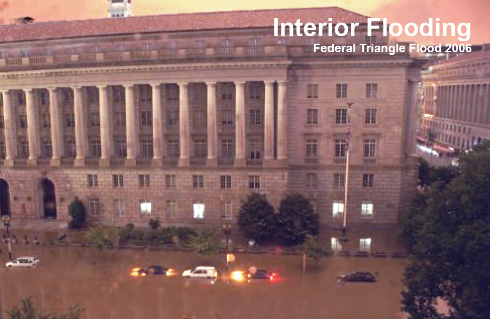
We are long OVERDUE for a storm that will flood large portions of Washington, DC with rainwater and sewage, causing billions of dollars in damage to government property and national treasures and threatening lives.
We have arrived at this dangerous point one step at a time over the past 230 years:
- first by filling in the Tiber Creek,
- then by filling in the Washington Canal designed by Pierre L’Enfant to channel the creek’s water and replacing it with undersized storm sewers,
- then by paving the city with impervious surfaces.
Now any heavy sustained rain will:
- run off the pavement,
- rise up through overwhelmed sewers,
- fill the low areas around Constitution Avenue,
- pour stinking filth into basements of government buildings (Smithsonian, IRS, National Archives, GSA) and
- stand for days.
The landscaping changes needed to prevent this are simple. Create a new lowest point in a safe place that can hold a large quantity of water (dig a broad shallow retention area near Washington Monument on the exact footprint of what was once there) and provide a drainage bio swale (a shallow low area) along the exact course of the Washington City Canal (adjacent to Constitution Avenue) to channel water to the retention area without overfilling the sewers. Gravity does the work. Once caught, the water can reabsorb safely over time or be pumped into the Potomac.
Practically, it may be difficult to make these changes because no one organization has clear authority and budget to solve this problem, the ground involved is so prominent, and because the mandates and budgets governing the involved organizations with juristiction do not address preserving the larger city in which they are embedded.
The proposed retention area site is now a patch of grass over rubble used to close and cover the Washington Canal when it had become an open sewer due to 19th century practices. We should do better today. There are many good design options for the drainage swale and retention area. They could be beautiful, appealing to visitors and office workers; recreationally, ecologically and financially beneficial. They could honor both the historic vision for our capital and what we have learned about urban ecology. And prevent a costly, dangerous, unhygienic mess.
This plan specifically addresses interior flooding, handling the runoff from rain, which is the most significant flooding threat to the Federal Triangle. It should make river flood mitigation easier, by keeping emergency personnel from working in floating sewage, and by functioning passively, so their efforts are not diverted.
This site brings together materials to support the plan, sometimes referred to as the “Dartmouth Plan,” developed by Karolina Kawiaka, who teaches architectural design and sustainability classes at Dartmouth College. Please consider sharing this information with people who would be affected by the coming floods – it is only valuable if people know of it.